See where hunters are. Stay out of each other's way.
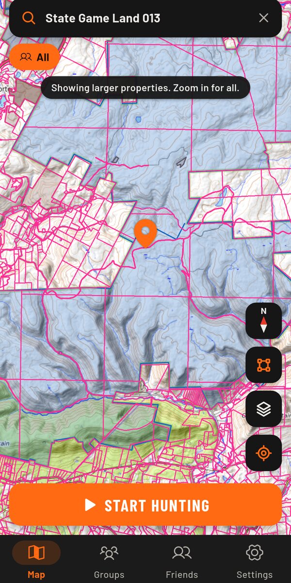
360 Hunter shows roughly where other hunters are in the woods, so you can head for the action or keep your distance. Property lines, owners, public land and hunting zones are on the same map, and your exact position goes only to your own group.
Three steps before you head out
- Set up your crewCreate a group, send the invite code to the people you hunt with, and draw your hunting grounds or pick them from the property lines.
- Start huntingTap Start hunting and choose how long. Your phone shows a notification the whole time, and sharing stops by itself when the time is up.
- Read the woodsSee your crew exactly inside your grounds, and everyone else as approximate areas, so you know where the pressure is before you walk in.
Everything on one map
Hunters near you
Everyone in hunting mode shows up as an approximate area under an anonymous name. Zoom out and crowded spots turn into a count, like +7.
Your crew, exactly
Group members see each other's precise position and trail, but only inside the group's hunting grounds, and only if each person switches sharing on.
Property lines and owners
Boundaries for every property, even zoomed out for the big tracts. Tap any piece of land to see if it's public or private, who owns it, and its size.
Owners: Pennsylvania so farPublic land and zones
State game lands, forests and parks are shaded. Wildlife Management Unit boundaries come with their antler rules and CWD status.
Zones: Pennsylvania so farHunting grounds in a tap
Draw your grounds corner by corner, or tap a property and use its whole boundary, even when it's made of many tracts.
Search the way hunters talk
Find a mountain, a town, "game lands 12" or just "3A". Filter by state and hunting zone, sort public land by size.
Map styles
Topo with contours, satellite, satellite with topo, classic USGS quads and street maps. Places you've seen are kept on your phone so they load fast.
Status and SOS
Tell your crew you're in the stand, tracking or heading out with one tap. If something goes wrong, SOS sends them your exact position, and a phone that goes quiet keeps its last known spot on the map.
Waypoints, wind and light
Pin stands, cameras, parking and sign, private or shared with your crew. See wind direction and speed for your spot, with sunrise, sunset and shooting light.
Who sees what
Nothing is shared until you start hunting mode, and it stops by itself after at most 16 hours. These rules are enforced by the server, not just the app.
Location points are deleted after 24 hours. No ads, no analytics, nothing sold. Read the privacy policy.
Common questions
Can someone use this to find my house?
No. Nothing is shared while hunting mode is off, so your location never leaves your phone at home. While you hunt, strangers only see a delayed, approximate square, and even your own group sees your exact position only inside the hunting grounds you have opted in to.
Where does it work?
The map, other hunters, public land and property lines work across the US. Property owners and hunting zones are Pennsylvania-only for now, with more states to come.
Is it free?
Yes, while it's in testing.
Is there an iPhone version?
Not yet. 360 Hunter is Android-only for now.
Does it drain my battery?
Only while hunting mode is on, when it uses GPS like any tracking app. When hunting mode is off it doesn't run in the background.
Can I trust the property lines?
They come from public records, which can be out of date, and they are not a legal survey. Always get the landowner's permission and check your state's rules before hunting.
How do I delete my account?
In the app, go to Settings and tap Delete account. Everything is removed immediately. More about deleting your account.

Coming to Google Play
360 Hunter is in testing with a small group of hunters. Want in, or have a question? Get in touch.
support@360hunter.app